 For professionals working in the field of law enforcement, firefighting, and search and rescue operations which require a planned and carefully controlled method of operation in an outdoor environment, it is essential to have as complete a picture of the ground situation as possible.
Such a picture can be obtained not just through the traditional use of sights and sound-based devices, but also through thermal imaging. The use of unmanned aerial systems and handheld imaging tools to provide thermal imagery of the immediate area of operation can be of great help in mitigating risk and saving lives.
What is Thermal Imaging?
Thermal imaging is a method of improving the visibility of objects in a dark environment. What makes thermal imaging better than near infrared illumination and low-light imaging is the fact that it works even in the absence of ambient light. It is also used to provide clear images of the immediate surroundings in the presence of various types of obscurants such as haze, fog, and smoke.
How it Works
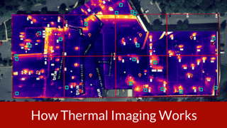
All objects produce infrared radiation as a function of their temperature, and it is this radiation which is used to create an image through the use of specialized imaging equipment. This emission, also known as the object's heat signature, is captured by a thermal imager, or a thermal camera, which essentially acts as a heat sensor which is capable of detecting the smallest changes in temperature of an object. The camera is used to collect information about the infrared radiation emitted by each object and convert it into electrical imaging. Since objects rarely carry the exact same heat signature even when lying within the same area, the objects show up as distinct from one another.
The temperature pattern that is created for the area is known as a thermogram. The information needed to create the highly detailed image is obtained from several thousand points of reference in the field, and the entire process takes less than a third of a second to complete. The clarity of the image depends on upon the resolution of the camera used, as well as the distance of the imaging device from the area or object under scrutiny. The type of imager to be used should be selected based upon target size and distance, types of surfaces, spectral response, temperature range, mounting and the desired signal processing.
Advantages Offered
We offer a customized system for law enforcement, fire rescue as well as search and rescue markets. Air to ground thermal imaging and easy to use aerial platforms from UAS THERMALS™ help save both time and money. Services offered also include commercial building inspections, infrared moisture analysis, precision agriculture and environmental and wildlife management. Arial drone packages provide real-time data to help assess large areas at a fraction of the cost and time of traditional methods.
Help your team gain the winning edge over the challenges you face in your job, and contact UAS THERMALS™ for all your thermal imaging needs!