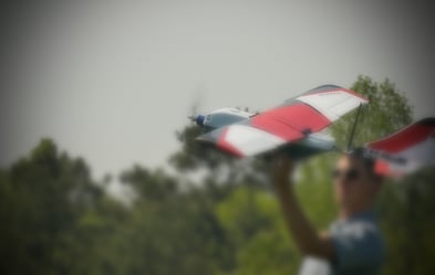
Unmanned aircraft systems have been a staple of military exercises in recent years, but a new breed of smaller, more maneuverable and economic drones are entering the commercial market. These sUAS (small Unmanned Aircraft Systems) are put to a variety of uses including product delivery, surveillance, and tracking.
One such area of the commercial market that is seeing rapid growth is surveying and 3D mapping. Traditionally, surveyors traveled the expanse of an area to conduct a visual survey or used aerial photographs to create a map of the land. With the introduction of drone technology, this process has become greatly simplified and more efficient.
Application of UAS for Surveying and Mapping
 The drone industry is seeing an explosion in applications for this technology. Uses that were once experimental will soon become mainstream. From mapping of large telecommunications structures, to agricultural and forestry applications, to large scale 3D mapping of land development sites, the range of uses is expanding every day. Below we explore a few recent projects which utilized UAS and mapping technology.
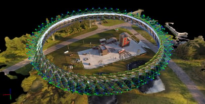
Industrial Structures Inspections
Telecommunications towers dot the land and inspecting them is expensive and potentially dangerous. Historically, large cranes were required to reach the top of these huge structures. A recent example in Washington revealed the advantage of using UAS for industrial structures inspections. Ryka UAS used a drone to inspect a telecommunications tower that was deemed unclimbable. With the goal of creating a 3D point cloud of the structure to identify, analyze, and design a new antenna mount for the tower, Ryka UAS used a drone to fly close to the structure and capture hundreds of images. Using Pix4D’s pixmapper software integrated with CAD software, they were able to create a 3D map of the tower. A project that would have required a crane crew and would have yielded mediocre results was completed within 3 days and produced an accurate digital representation of the tower and useful data. Read more about this story from Pix4D here.
Agricultural and Forestry Mapping
Another recent Pix4D project produced exciting results and revealed potential new uses for UAS, 3D mapping, and multispectral imagery in the field of forestry and vegetation mapping. While recognizing the value of multispectral images to capture what the human eye cannot see, yet realizing that 2D images have limitations, they used their exclusive software to bridge the gap. The resulting 3D images of giant sequoia trees in Whitaker’s Forest in California give researchers access to information that was previously unavailable.
According to Pix4D, “The end result is a 3D NDVI point cloud, where plants can be observed and scouted in their entirety, adding a new dimension to an industry previously constrained to information from plant canopies. There are several direct implications of this breakthrough, and we are excited to see what researchers, companies, and industries will do with this data.”
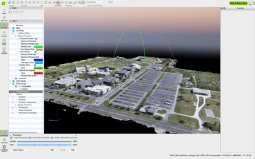
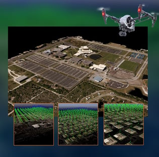
Land Development
When a university has plans to spend nearly $75 million on an expansion project, they need up-to-date data about their current infrastructure. That’s why Eastern Florida State College recently tapped Planet Inhouse, an aerial and industrial imaging solutions provider and BRPH, an international architectural and engineering firm, to map 196 acres of their campus in Melbourne, FL. By capturing 435 georeferenced images and stitching them together to create an ultra high-resolution orthomosaic map, they were able to provide an accurate image of the campus that will be used in planning and development.
 Todd Reed, Principal at BRPH, sees great potential in offering real-time aerial views before, during, and after project completion. Reed, who is also a certified thermographer, elaborates, “this method of site planning, gathering data, and then converting that data into highly accurate and visually detailed project plans does more than assist in the execution process of all phases of construction, the data and imagery captured helps everyone involved effectively manage large-scale projects and finish on time.”
Aerial photogrammetry can be used for multiple proposes. According to Reed, “It can be imported by civil engineers as verification of surveys and publicly acquired GIS data. The textured mapped geometry can be utilized by marketing to create sequencing visualization to win competitive design bids with informative graphics. The photo montage base aerial can be used by architects to do conceptual site planning guaranteeing they have up to date site information to make informed design choices. Because of its multiple uses, aerial photogrammetry is far and above a good investment when properly managed and distributed to the team in formats they can use.”
Advantages of UAS Technology for Surveying and Mapping
Using drones to carry out surveys and 3D mapping is a good proposition for several reasons:
- Faster Work Completion
 The task of completing a land survey manually is a long and arduous one. It requires traveling over large tracts of changing terrain several times to get an accurate assortment of pictures that can be later used to create a map of the area. Inspecting industrial structures is also complicated, often requiring heavy equipment to access them.
With the 3D mapping drone camera, the entire device is airborne and remotely controlled by a licensed UAS pilot. This means the length of time spent traversing the area is significantly reduced.
- Immediate Results
The new technology being used in 3D mapping drone cameras means that a series of high-resolution images are compiled from the survey and fed directly into the software. The software calculates the angle at which each image was taken to get an accurate reading of the terrain through the images. The computer then creates an exact 3D replica of the land from these photos. In an ordinary processor, the time taken to compile the data could number in several thousand hours, but the new drone survey technology accomplishes the work in less than five hours.
- Reduced Cost
One of the main advantages of UAS for land surveying and 3D mapping is the reduced cost. A UAS controlled by a single worker cost less to maintain and deploy than using a team of workers to conduct the survey or gathering aerial images via manned aircraft or satellite. Compiling the results and creating a map from the recovered data is significantly less expensive when using 3D mapping software. In addition, relying on computers to carry out most of the work means there is a reduced chance of costly errors.
 “Aerial thermography, large-scale mapping, surveying and modeling, none of this has ever been more affordable.” Says Todd A. Hillhouse, CEO and Chief UAS Pilot of Planet Inhouse. “We are able to capture high-resolution large-frame images from aerial systems and convert those images into georeferenced orthomosaics and 3D models for surveying, city modeling, large-scale mapping, urban planning, cadaster and more.”
The UAS THERMALS™ professional team offers UAS and thermal imaging technology tailored to land surveying and 3D mapping applications. When it comes to large surface area surveys and mapping, you need the tools and expertise that can help you reliably cover the ground and provide the real-time data you need in a timely and cost-effective manner. You can learn more about the technology we offer by visiting us here.